Trip Report
History: Faraway Arch, as far as we knew, had been seen only from the air. I heard about it in 2013 from Andy Waddington (http://andrewwaddington.com). In fact, one can see it well from the ground just below Belvedere Arch. Some info on Faraway Arch can be found at the Natural Arch and Bridge Society site: here and here. Belvedere is also listed as AZ-126 on the subscriber-only site http://arches.stonecanyonadventures.com. And these arches are mentioned in Jay Wilbur’s note in SPAN, vol. 5, no. 4, where one finds:
“From the air it does not appear that [Faraway] arch is visible from the canyon bottom. Short of making a technical climb, it is likely that the arch can only be viewed from the air.”
To our surprise, we found that Faraway Arch is indeed well visible from the ground (see second picture in photo section). Wilbur’s article reports: “During the flight, we located an arch first shown in Bill Leverton’s ‘Faraway Arches’ video, KSTP-TV Phoenix”, so it might well be that Bill Leverton gets credit as the discoverer.
Belvedere Arch is our name for V821 (Arch 21 in Chapter 8 of the Vreeland compendium); it has been known for a long time. But it really deserves a name-—the size and location are both badly incorrect in the Vreeland book—and Bill Briggs and I agree that Belvedere Arch is a good name. Several arch aficionados agree, so we will use this name. Both these arches had been seen and photographed from the air on July 26, 1993, on a flight by David Brandt-Erichsen, Gus Scott, and Jay Wilbur (SPAN 5-4). Both arches are “alcove arches”, a common type.
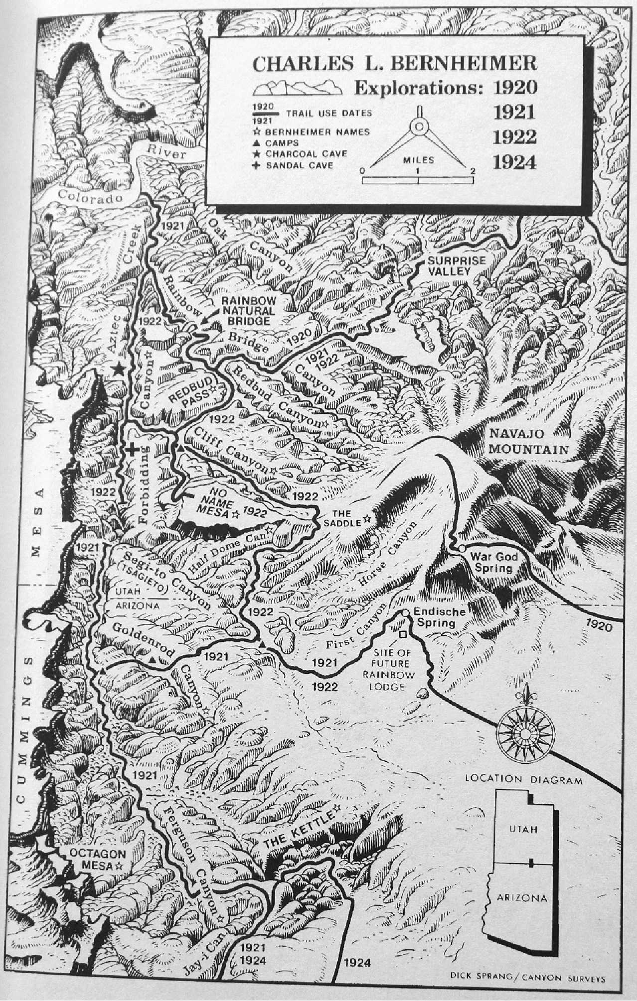
This map (from Rainbow Bridge, by Charles Bernheimer, 1926, reprinted by Center for Anthropological Studies, 1999) shows the area and what Bernheimer’s many expeditions accomplished. I highly recommend this book. The map was drawn by Dick Sprang, a comic-book artist of Batman fame.
Reconnaissance: On May 28, 2016, Bill and I did a one-day-from-Page recon to the area by boat and foot (a 16-mile hike and 90 miles of boating). We explored the side canyon of Cliff (Arch View Canyon is a good name for it) and decided that there were feasible routes for competent climbers with adequate rock gear so that one could get to the top of "Faraway Mesa" which would put us above Faraway Arch. So we set up an expedition for October 2016 and recruited Katie Larson (Montezuma, Colo.) and Jim Illg (Boulder, Colo.), both very experienced in desert backpacking, to join us. We needed boat help, and Jim and Pam Bradley, as well as my wife, Joan Hutchinson, joined us in a rental boat from Wahweap to Rainbow Bridge, which they then returned the same day (Oct. 19). Weather all week was perfect: no clouds, moderate temperatures day and night.
Preparing: Saturday: Joan, Jim, Pam, and I drove from Silverthorne to Page via Moab; about 9 hours driving.
Sunday, Monday, Tuesday: Hike (South Coyote Buttes, White Pockets, Buckskin Gulch) and prepare. On Tuesday I got the required Navajo Nation backcountry permit in LeChee and arranged the boat rental details with Jim. And Joan and I did a nice short hike in Wiregrass Canyon out of Big Water. Jim, Bill, Katie arrived in the evening and we stayed at the Lake Powell Resort in Wahweap.
Starting: Wednesday, Oct. 19. We left around 7:20 for the uneventful boat ride to Rainbow Bridge. At the bridge we saw that the Park Service is building an improved trail around the uphill side so that people can avoid the trail that goes under the bridge, which is frowned upon by the Navajo. We started hiking at 9:30 and after 6.2 miles reached camp at the bottom of the descent from Redbud Pass at 12:50 (times are Mountain Standard Time; i.e., Arizona time). Possibly this camp is Painted Rock Camp named by Bernheimer in 1921; not clear. Packs were heavy (45 pounds for me, more for some of the others), but it all went well. This was my first backpack in six years so I was pleased with the effort. There was plenty of water in Redbud Creek and Cliff Canyon despite no rain for a couple weeks.
After setting up camp and examining the excellent Basketmaker pictographs nearby, we headed up Cliff towards Faraway Mesa for a recon. Bill and Jim headed up the side canyon (Arch View Canyon) while Katie and I examined the toe route from near the confluence of Cliff Canyon with the northern side canyon. Katie and I were unable to surmount a small obstacle (we could have done it if we had to) and so never got to the start of the crux section. Bill and Jim came to the same spot after finishing their upstream exploration and surmounted that small barrier to the base of the crux crack; they reported that, contrary to our expectations, it was unclimbable by us. And they thought that the terrain upstream would yield nothing useful for us on this trip. That was a bit depressing, but the area is so wonderful that we had no problem filling four days with superb explorations.
Funny story of the day. All our information, including the May recon up Arch View Canyon, indicated that Faraway Arch was not visible from the ground in this area. As we left the boat, Bill suggested that a goal could be to see the arch this day, by going far up Arch View Canyon. He and Jim went up there but did not see it. But after our recon of the toe, Katie and I headed up Arch View Canyon and, right under Belvedere Arch, Katie spotted Faraway. This was shocking to me as Bill and I had been there in May, but I guess we did not turn our heads in the right direction. This yielded an excellent portrait of Faraway Arch and a good story back at camp.
Day Two, Thursday. We decided to go for Redbud Spine, another main objective for us. This is the ridge that separates Cliff Canyon from Redbud Creek and continues a long way up. I had studied this on Google Earth and thought I had a good ramp to try: it started a short distance upstream from camp. It all worked (two short roped pitches; the first could be avoided I think) and it was very exciting to be up on this spectacular feature. Low down on the route we appeared to be stuck, but there was a "miracle ramp" that allowed us to push through to a steep gully and so reach the base of the second roped pitch. There was no sign of human passage: no Moqui steps or anything else. Well, at the top we did find the annoying helium balloon remnant that one occasionally sees in remote places. We got to the top of the spine which is covered by a thin layer of Carmel sandstone and proceeded over several ups and downs to a spot (5750 feet; one mile along the crest) allowing great views of the two large arches and the cliffs that surround them. Probably one can get to behind Belvedere Arch this way, but the going up top was not fast so we stopped at the viewpoint.
Day Three, Friday. Hourglass Exploration: We went downstream in Cliff and then a short way upstream in Aztec to a side canyon that I thought would get us out of the canyon. The side canyon failed at steep pouroffs, but the nose of it had a likely route. Instead of pursuing it, we headed farther upstream and eventually found another way up (just before the pools in Aztec, and after descending a cowboy ladder (a tree) that has been in place for at least 20 years) but it was too far from the Hourglass to be useful. It required a roped pitch (Bill led) to get out of Aztec and the subsequent large side canyon did work, with some Moqui steps to escape it on its left (looking upstream) side. We did some pleasant exploring of the Navajo domes in this area and then backtracked and returned to the first route in that first side canyon, which Bill led masterfully with no protection. This route had some Moqui steps but they started several feet off the ground. It seems clear that the starting point was higher when those steps were made (this phenomenon is clear also from some rock art that one occasionally sees well above ground level). I then followed the route (both Bill and I needed a lift from Jim to get off the ground to the first of the shallow steps) and was very pleased to see that the route led easily to the Navajo domes that would surely offer easy passage. We left the rope in place overnight and returned to camp.
Day Four, Saturday. We returned to the rope, making good time, did the pitch (5.6 A0), and then found easy ways through the domes to the level of the Hourglass. Our route might not be the easiest way out from this area of Aztec Creek, but it was what we found and it worked well for us. We headed west until, finally, an Hourglass sighting. What a great feature! It is an "abandoned arch". We spent quite some time there and then returned to camp the same way and moved cam to a great campsite (“Second Water Campsite”) at the confluence of Redbud and Bridge creeks to make the final hike out to the boat on Sunday easier.
Day Five, Sunday. We reached Rainbow Bridge in plenty of time for the boat and enjoyed the ride back to Page; captain Paula took the boat on a side trip into Antelope Canyon, but one could not see much of the real canyon. She stopped the boat once to pick up a plastic bottle. A lot of effort goes into keeping the lake and beaches clean. Lake level this week was 3610 feet, seven feet higher than on the May recon trip.
Post-Trip: Monday: Katie and I met Bill Wolverton in Escalante and, with three other canyoneers, hiked to the Cosmic Ashtray (which Bill would like to see called the Cosmic Juicer). We did this by a route over a steep high bump to its east. This was about a nine-mile day, and the weather held, though rain hit soon after we returned to the cars.
Tuesday: Katie, Bill, Carol Petrelli, and I did the Upper Muley Twist trail (counterclockwise) with a small side trip between two of the amazing Wingate lobes; ten miles. One highlight was a beautiful large Douglas fir tree in a side canyon. Then Katie and I drove to Moab, stayed with her friends Natalie and Steve, and returned to Silverthorne Wednesday morning, ending a 12-day trip for me.
An article about our trip appeared in the Winter 2017 issue of SPAN, the journal of the Natural Arch and Bridge Society. After our trip we learned that in 2005 Bob Schwartz and Dave Tate landed a helicopter (a Robinson R-44) just above Faraway Arch; their report and pictures appeared in Lake Powell Magazine, Fall/Winter 2005-2006, pp. 54-55. The report does not indicate that they received a permit from the Navajo Nation for the landing.
Update: On May 5-8, 2017, Bill Briggs, Jim Illg, Dave Irwin, and Bart Miller returned, carrying a lot of climbing gear and camping in the same spot. They used the tour boat both ways. Over two full climbing days they attempted several technical routes to Faraway and Belvedere, and while they explored some new terrain, none of the routes offered the desired passage to either arch. Also, in June I learned that Steve Allen, who has spent countless days in this area, has never been to Redbud Spine and does not know of anyone who has. Thus it seems likely that our group was the first to visit this ridgetop.