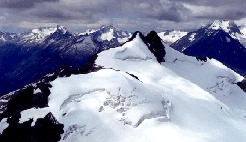
Western View from David Peak
The view west from the summit of David Peak (first climbed in 1946 by my sister's father-in-law, David Hope-Simpson, now of Wolfville, Nova Scotia), with Cony Peak and Twin Towers visible above the Spillimacheen Icefield. The background is interesting: the rock-and-snow peak above large glaciers on the left is Moby Dick. A snowy bump to its left is Typee. The large peaks just left of Cony's top are Ahab and Butters. The snowy bump between Ahab and Moby Dick is a ski summit called Little Ahab (also known as The Poopdeck) that is often skied from Battle Abbey (the rock island in its middle makes identification easy). The long rocky ridge in front of Moby Dick is Schooner Ridge; Battle Abbey is just on the other side. The large peaks in the clouds on the right are Beaver and Duncan. Just right of Twin Towers is a ridge whose southern end (not visible in photo) is a summit that has been skied to from Battle Abbey. We did it (March 1999) and named it Queequeg, a name that seems to have stuck with the Battle Abbey crowd.
The foreground is also interesting since it shows that the summit of David is very close in height to Cony and Twin Towers. The map and guidebooks have: Cony (9340'), Twin Towers (9300'), David (9250'). From this photo, it seems very possible that David is closer to the others in height, though this is admittedly unscientific. Using a water bottle as a level indicated that the heights were close. Yes! I have obtained a newer TRIM map from British Columbia, which gives the heights of these three as 9396', 9396', and 9413', respectively: so David has been promoted to king of the range.