Post-Trip Research: First Ascender Sam Silverstein; Queen Elizabeth II visit to Golden and first map of the area by Sam.
Sam Silverstein spent the summer of 1959 exploring and mapping the Battle Range and ascending a number of its principal peaks. In July, he, Douglas Anger, and Fenwick Riley traveled on foot via Silent Pass to the Nemo Glacier, fording both the Duncan River and Houston Creek en route. They recovered airdrops placed in late June on the Nemo Glacier and made the first ascents of Mt. Nemo, the eastern summit of Evening Spire, and the eastern ridge of Mt. Nautilus.
Silverstein, Riley and Anger placed two air-drops: one on the Nemo Glacier and one on the Houston Glacier. Poor visibility, and the fact that their pilot, Charlie Thompson, had never been in the area, led Silverstein and Riley to mistakenly place a second drop on the large glacier on the southern side of the head of Houston Creek. Not until they reached the summit of Mt. Nemo did Silverstein and Riley recognize their mistake. "Well Doug, looks like we put the groceries in the wrong icebox." For the rest of the summer Silverstein referred to this glacier as the Wrong Glacier and the peak at its head as Wrong Peak.
Having completed ascents of Nemo, Evening Spire and Mt. Nautilus, Silverstein, Riley, and Anger descended a steep snowfield at the western end of the Nemo basin (just below Feather Spire) to Houston Creek, crossed Houston Creek and traversed the alp-lands on the north side of Houston Creek to an alp below Mt. Moby Dick. From there they ascended Mt. Moby Dick. A two-day snowstorm caused them to abort their attempt on Mt. Proteus (then named Mt. Butters). With food supplies dwindling they crossed to Butters Creek, passing near the present site of Battle Abbey. Four days later they reached Silent Pass. The following day they reclaimed their car at the end of the McMurdo Creek road, and returned to Golden, B.C. It should be noted that Anger et al had tried Moby Dick in the summer of 1958. They did get Butters and Ahab, but retreated from a high point on the ridge between Pequod and Moby Dick. This earlier group named Moby Dick because of its aspect from Butters Creek. All this is well described in the 1960 issue of the Canadian Alpine Journal.
Silverstein spent the next week at the Hotel Fridham in Golden (whose owner at the time was one of the sons of either Walter or Edward Feuz), repairing equipment, purchasing and repacking food for an airdrop onto Houston Glacier, and waiting for two friends from Dartmouth: Charles Plummer and Thomas Marshall.
During this wait in Golden, a Harvard Mountaineering Club group arrived. The Harvard group planned to explore the Northern Purcell Range. Silverstein helped them pack food for an airdrop and shared the expense of the airdrop with them. They again employed Charlie Thompson who flew them over their respective airdrop sites in the Purcell and Battle Ranges.
Plummer and Marshall arrived in Golden in early August. Silverstein led the three over Silent Pass and up Butters Creek, and over into Houston Creek and to a small pond at the head of Houston Glacier. They recovered the airdrop Silverstein had recently placed, in the right place on the Houston Glacier this time, and waited for the weather to clear. It never did and for the next month they endured snow or rain nearly every day. This led them to name the site at which they were camped "Never-Sun-Col" (now known as Houston Pass). From this camp they ascended Mt. Scylla in one long day, using the west side of Billy Budd and the Chinese Wall. The continuous rain and snow prompted them to move camp to the valley of Oasis Lake. As they entered the valley the clouds parted and the sun shone. Tom Marshall commented, "A veritable Oasis." And so it was named. From their Oasis Lake camp they climbed into the Wrong Glacier basin, recovered the June air-drop, and ascended Wrong Peak. Two days later, in cloudy weather, they ascended the east ridge of Mt. Goodrich, which was named by Plummer in honor of the Dartmouth College librarian who had assembled a superb collection of mountaineering journals and books in Dartmouth's Baker Library. The three then returned in an intense snowstorm to Houston Pass in hopes of climbing Mts. Escalade and Proteus. Snow and rain persisted for the next three days. On the fourth day, with the rain still coming down, Plummer announced he was getting dishpan body from sleeping in a damp sleeping bag, and was ready to leave the mountains. Marshall and Silverstein agreed and the three returned via Butters Creek to Silent Pass and their car at the end of McMurdo Creek.
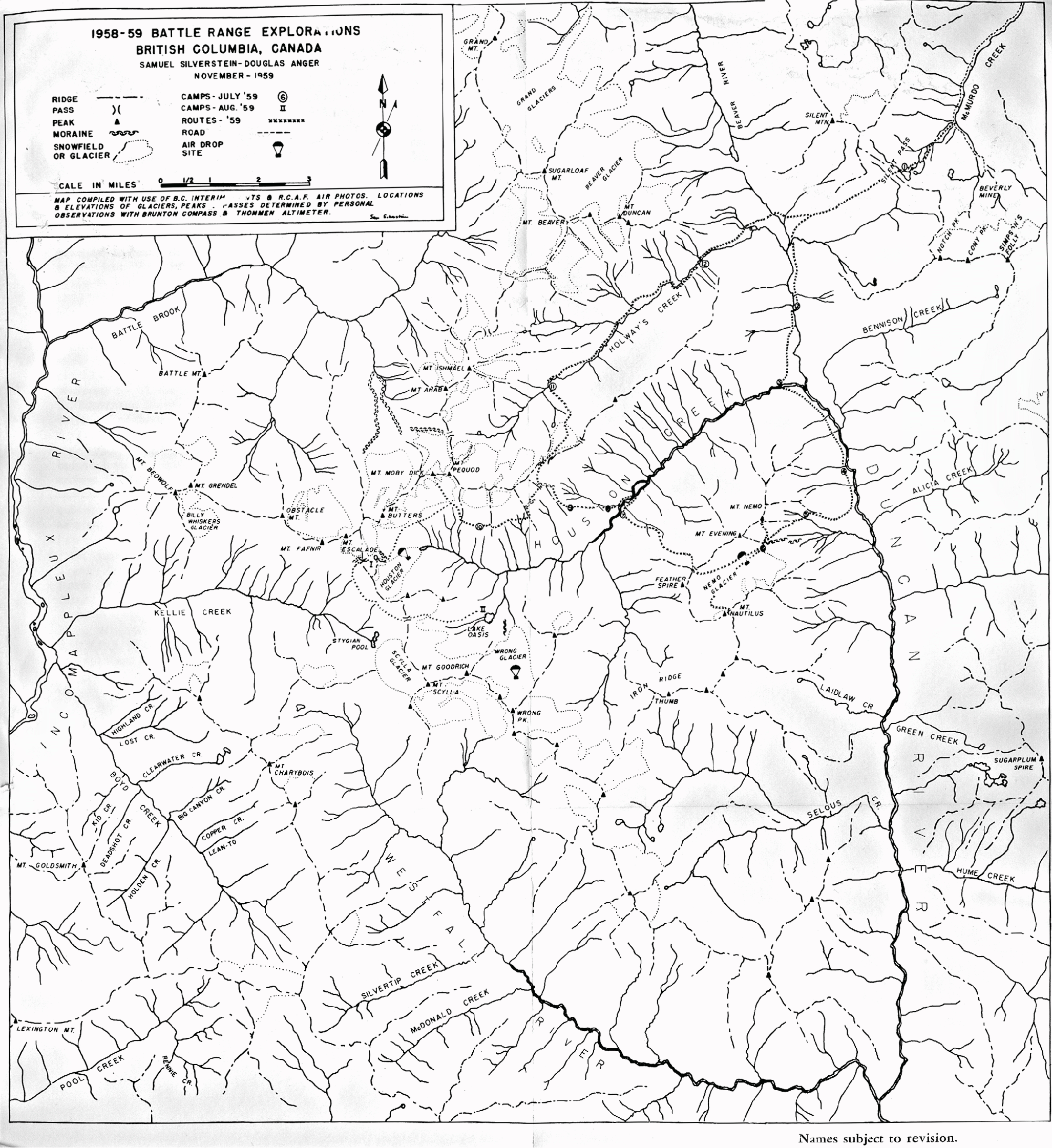
Had the weather been better they would have attempted the Thumb on the Iron Ridge and Mt. Escalade. Nevertheless, it was a satisfying summer of exploration and climbing. Silverstein and Anger subsequently published a full description of the July and August expeditions in the Canadian Alpine Journal 1960. The article is illustrated with photos of the principal peaks of the Battle Range, and contains Silverstein's map of the Range.
Sam continued as a serious expeditionary mountaineer for more than a decade: he was co-leader of a six-man team that in 1962 made the first ascent of Denali's SE Spur and co-organizer of the American Antarctic Mountaineering Expedition 1966/67 that made the first ascents of Mt. Vinson, the highest point in Antarctica, and five other Antarctic summits. In 2006, the 40th anniversary of the American Antarctic Mountaineering Expedition expedition, Silverstein and three other members of the 1966/67 expedition returned to the Sentinel Range as guests of Antarctic Logistics and Expeditions. They placed a plaque on Mt. Vinson's summit in memory of four members the 1966/67 expedition who were deceased. In honor of the accomplishments of the 1966/67 expedition the USGS Committee on Antarctic place names named the subsidiary summits of Mt. Vinson after each member of the 1966/67 expedition.
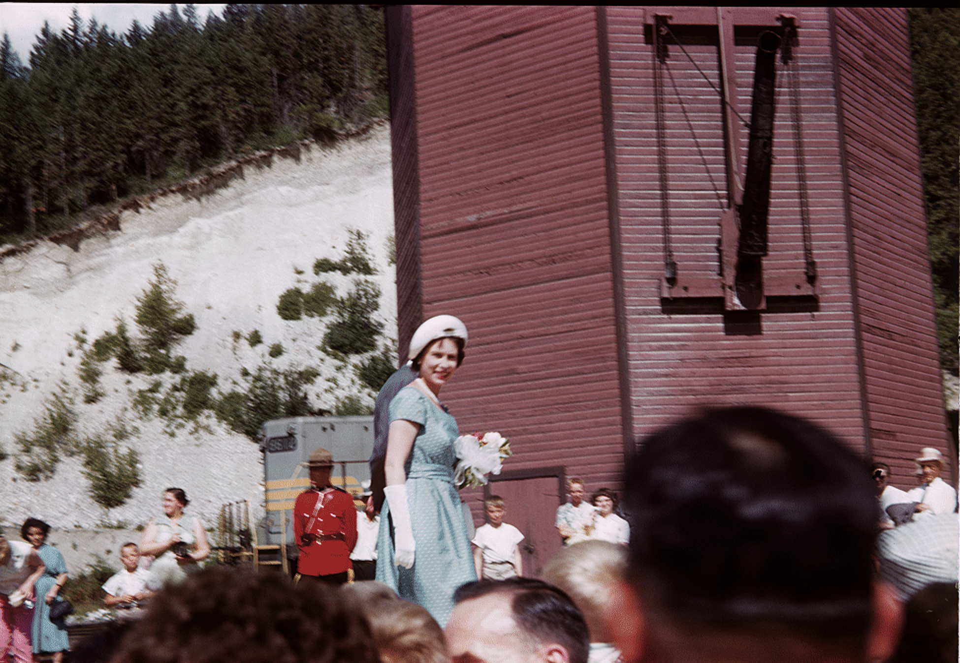
On the day preceding their July Battle Range expedition, Silverstein took this shot of Queen Elizabeth II, who was visiting Golden, B.C., on her first tour of Canada. Silverstein says he took it as an auspicious omen that the Queen of England came to Golden to see his expedition off!
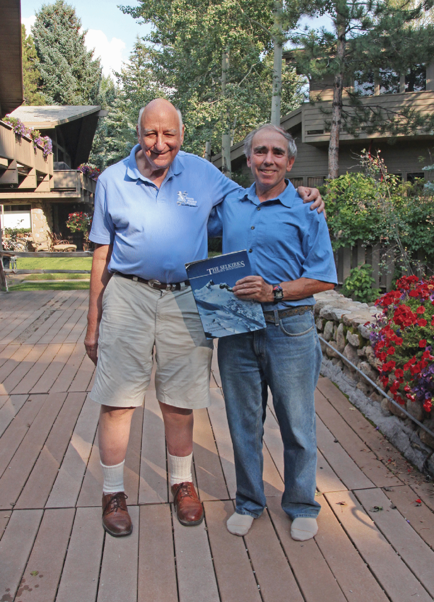
In August 2015 Stan Wagon and Sam Silverstein met for a pleasant few hours in Aspen, Colorado. Our ascents of Moby Dick were separated by 56 years! (Photo by Rudi Brooks)
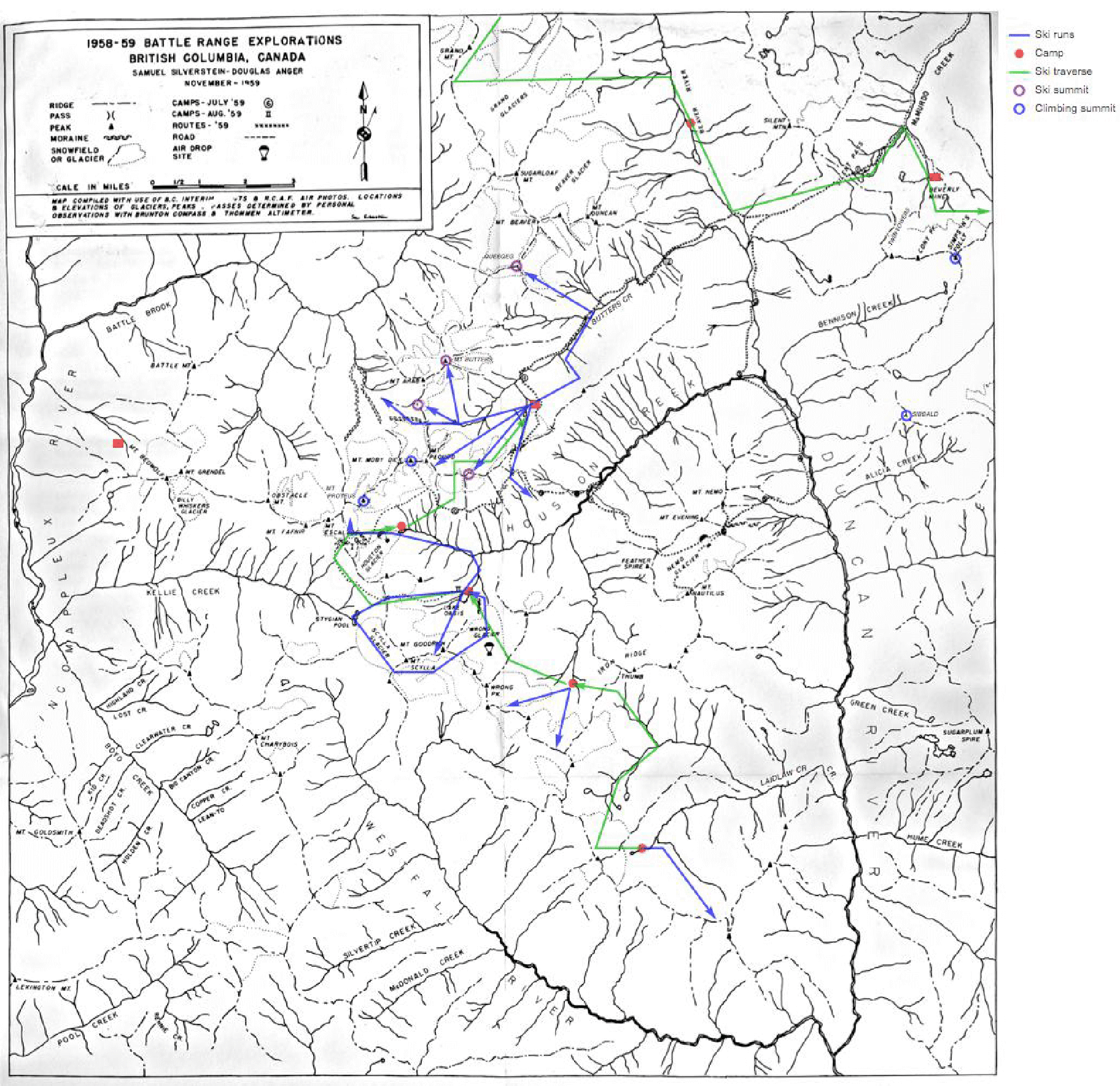
Here is the map Sam made in 1960, printed in the 1960 Canadian Alpine Journal. Some names have changed since then: Holway’s Creek on the map is Butters Creek; Mt. Ishmael is Mt. Butters; and Mt. Butters is Mt. Proteus. Also Laidlaw Creek is misidentified. The creek marked Selous is Laidlaw. And Notch Peak is now Twin Towers, and Simpson’s Folly (named after David Hope-Simpson, my sister’s father-in-law) is now David Peak.
The version below is annotated according to my history. Green = ski traverse routes; purple marks summits skied to; blue marks summits climbed; red marks camps (or Battle Abbey or McMurdo Cabin).
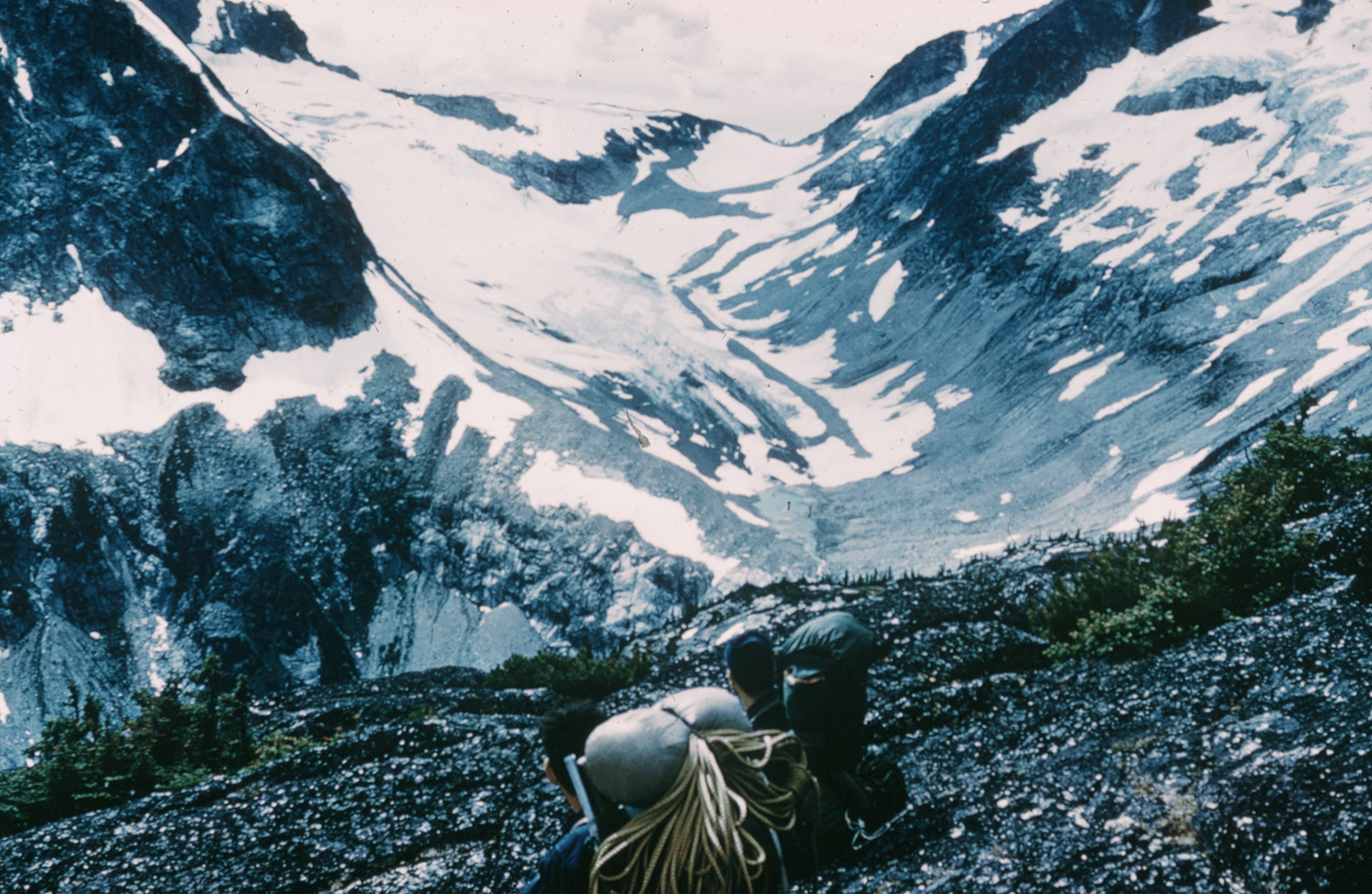
Here is a view of Houston Pass and Glacier by Sam from 1959. Houston Lake did exist at this time, though it was smaller than it is now.